


Last year a block of earth 20 times the size of Coors Field slid downhill at upwards of 80 mph, bowling over a forest and killing three Coloradans near Collbran. Two decades prior, and not too far away, a football-field-sized chunk of I-70 heaved upward 14 feet—making the roadbed more suited to monster trucks than Camrys.
As the nation’s cradle for steep slopes and high mountains, Colorado experiences over a thousand mass movements of earth—each year.
Should we be concerned?
Most of these are as small as your backyard, but some are the size of towns. Although there are many names to describe different types of downslope earth movements, we can lump them together as “landslides” sensu lato. Such landslides are to dirt/rock as avalanches are to snow, except that landslides are a year-round affair.
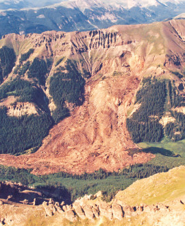
Approximately 10.5 million cubic yards of material mobilized when heavy rains and meltwater triggered a catastrophic slope failure above West Lost Creek in the San Juan Mountains in 1991. Eyewitness reports suggested that the slide moved nearly half a mile in 30 seconds. Photos from CGS archive.
Fortunately, there is some predictability and patterning to such events. Many are triggered by rainfall—whether from a hovering storm system or an afternoon downpour. And those wildfires we’ve had in recent years? They just exacerbate the situation. Vegetation-less landscapes slough off curtains of loose sediment, turning rainy runoff into a wall of moving mud.
Water infiltration, which peaks when snowmelt wicks its way down into cracks and pores in the earth, is another big cause of Colorado landslides, generating hillside slumps, rock slides and embankment failures. These types of landslides can lag behind their triggering event, sometimes occurring months after a snowmelt or late summer monsoon because it can take a long time for the pores and cracks in soils and rock to become filled with slowly infiltrating meltwater. Not only does the water-saturated dirt become heavier, but water also reduces the frictional characteristics of the soil, inhibiting its ability to “hold” its place on a slope.
Colorado’s large daily temperature variations are another cause of landslides. Think of those days when you walked the dog with morning frost on the ground but later stepped out for lunch on a sunny 50-degree afternoon. These temperature fluctuations cause expansion and contraction of rock and soil as water in pore spaces and rock fractures repeatedly freezes and thaws. Called ice-jacking, it triggers downslope movement of unstable earth. It’s the same thermal process that causes so many potholes to form in our roads.
Not surprisingly, high-elevation communities are in the belly of the landslide-producing beast, much as they are for avalanches. Just pick your favorite pass. Loveland, Red Mountain, Slumgullion—they teem with downward-moving rock and dirt. Ditto for Colorado’s high parks and mesas, where slides are catalyzed by flood-and-furrow agricultural irrigation practices together with our bad habit of lopping off the toes of slopes during development.
And the Front Range? Western Colorado Springs is such a classic example that it ought to be included in the FEMA training handbook. Much of the Springs was developed over the last few decades, with builders siting houses on ancient landslides or slide-prone surfaces. It’s like a perfect storm. Grade some of these sites, exuberantly irrigate the turf, and add a wet winter or two and … kasloosh!—landslides let loose. Ponder it next time you’re sipping chai at the Broadmoor.
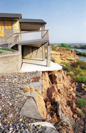
This home near Grand Junction was destroyed by a landslide caused by the Colorado River undercutting its own bank. Many of the stream banks in Colorado that are composed of soft sediments are prone to slope failure, especially around meander bends.
Many other parts of the Front Range are also at risk. The same tectonic processes that tilted up those beautiful red sandstone beds to become the Flatirons, Red Rocks Amphitheatre, Roxborough Park, and the Garden of the Gods? They also tilted upward the slippery, poorly consolidated shales that underlie many communities … which can slip and buckle when not developed with caution.
Surprisingly, Colorado doesn’t require all builders, municipalities or agencies to assess risk before commencing development. Moreover, just because a property (home, road, business, farm) was platted back in the day doesn’t mean that it was ever assessed for geohazards like landslides, underground faults, abandoned mines, or swelling or collapsible soils.
Fortunately, the lion’s share of large land movements move slowly, perhaps creeping an inch or a foot per year. And, many landslide-prone areas and regularly moving slides are known. See coloradogeologicalsurvey.org/geologic-hazards/landslides-2/
There’s a saying among landslidologists: “Some landslides you fix, and others you name.” Fixing landslides includes buttressing the earth, holding it back using soil- or tie-back anchors, or making it less heavy by drying it out or removing weight or earth from atop it. And the landslides that get named? Usually we address them by avoiding them and/or monitoring them with devices that notify authorities when their rate or distance of movement changes markedly.
The good news? Fatalities from these geohazards are extremely rare. Also, Colorado has a bunch of dedicated “slide scientists” who are embedded in places that count—like CDOT, CGS and the USGS.
Like the study of earthquakes, the study of landslides has moved from reactive to proactive in the last few decades. With new laser-based scans of ancient and current landslides, Colorado’s landslide science could soon be predictive, employing risk-based asset management principles to protect people and property.
James Hagadorn, Ph.D., is a scientist at the Denver Museum of Nature & Science. Suggestions and comments welcome at jwhagadorn@dmns.org.

James:
Thanks for another great article.
Richard Crabb
Happy to oblige. Any suggestions for future topics? Am here to help and will give most topics a shot.