


MLK Construction 2017; Open 2018
A Stapleton land use map shows the route for the new 4-lane road that will go from Havana to Peoria. The current 2-lane road curves at Moline and intersects 25th Ave.
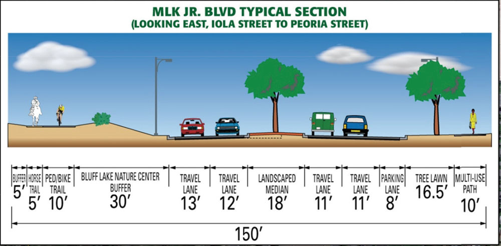
A typical section of the new roadway looking east from Iola to Peoria.
The Denver Regional Council of Governments (DRCOG) on April 15 finalized the funding decision that will allow Martin Luther King Blvd. to be built as a four-lane road from Havana to Peoria. Although funding has been designated, construction won’t start until 2017, and the road won’t be open to the public until 2018.
The project cost will be $15 million, with $7,172,000 in federal funds and $7,828,00 in matching funds from TIF revenues between 2015 and 2017. A minimum of 20% local matching funds was required, and the higher level of matching funds gave the project an edge in funding effectiveness (how much can be done with the federal money being awarded).
The project met specific criteria that were required for this funding. Doug Rex, DRCOG director of transportation planning and operations said relieving congestion and increasing safety were high priorities. This project is also considered to be an important part of the long term regional transportation plan. It provides an alternative route to I-70 and Colfax Ave, both of which are over capacity in peak periods, according to the Denver Department of Public Works.
DRCOG received 140 applications for a total of $500 million in funding requests under this Transportation Improvement Program (TIP), of which 47 were funded with $175 million in federal funds.
The project adds two additional lanes to MLK Jr. Blvd from Havana St./Iola Street and a new 4-lane roadway from where MLK turns south into Moline St. to Fitzsimmons Pkwy/Peoria St. intersection. The project will also include:
–18-ft landscaped medians, turn lanes, and a 16.5-ft landscaped tree lawn
–A detached 10-ft wide multi-use concrete path on each side, a 10-ft wide multi-use concrete path and a 5-ft parallel soft trail outside of a 30-ft. buffer from the Bluff Lake Nature Center
–Several existing access consolidations, bus pads, new or improved traffic signal connections, bicycle detection, and a median pedestrian refuge at Peoria St.
–A north-south connection at Moline
Information from Denver Public works predicts there will be about 28,000 drivers daily on the new roadway by the year 2035.
Quebec Construction 2019; Open 2020
Quebec looking north. Graphic courtesy of Denver Dept. of Public Works.
Funding to reconfigure Quebec to four lanes and optimize vehicle flow through intersections by adding turn lanes was granted by the same DRCOG program that funded the MLK extension.
Construction is expected to start in 2019 and be finished in 2020. The total project cost of $23 million will be split evenly between federal funds and funds from City sources, spread over the next four years.
The improvements on Quebec St will be from south of 13th Ave to 26th Ave and will include the following:
–One additional lane in each direction from 13th Ave to Montview Blvd
–Receiving and/or turning lanes at intersections of 13th Ave, 14th Ave, Colfax Ave, 17th Ave, Montview, and E 23rd Ave
–A continuous 5-ft sidewalk facility with a 3-ft buffer
–New or concrete bus pads, transit amenities, and bike parking
–New or improved traffic signal interconnection
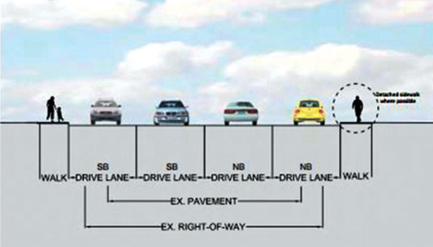
The graphic below shows the difference between existing and future pavement and right of way.

I drive a big truck. I also did volunteer work for Americans with Disabilities. While in Denver and parked at the truck stop on Quebec, I tried to walk to Walmart for food and supplies and nearly got killed. I have been through the State of Colorado many times, and you suck for sidewalks and handicapped access. The people of Colorado should be fighting for handicapped access and a simple sidewalk to safely travel on.
Is there a In Trac Open space (green) running the whole length of 25th around Moline and towards Peoria? I have seen that on other maps as well.
I still don’t understand how they are going to expand to 4 lanes from 13th up to Montview. There are houses right next to the road already so an expansion literally would put you at their doorstep. Is there a link I can go to so I can see the plans other than a photo? I have been to the quebec alternative site but does not give much information at this time.
I can’t believe that anyone along Quebec would shovel a 5 ft wide sidewalk the length of their property. And, the street will be just feet from their front door. It seems those people are being punished for the City’s poor planning on Quebec. There are lots of young families moving into those homes and they will probably pay the price when they want to sell. The city should have planned better years ago when they had a chance.
We have requested further information from Denver to answer your questions. The 24-page document distributed after the Quebec Alternatives meeting last summer shows on pages 19 & 20 how the right-of-way will affect houses on the portions of Quebec that have different widths now. That document is at the end of the article at https://frontporchne.com/article/recommendation-relief-quebec/.
It says for 50% of the properties, the roadway will move closer to the buildings by 5′ or less (the graphic shows the street by those homes will increase from 45 to 48 feet wide, plus 8′ sidewalk, and the new roadway will be within the existing right-of-way).
For 25% of the properties, the roadway will move closer to the buildings by 10′ or more (the graphic shows the street by those homes will increase from 29 to 48 feet wide, plus 8′ sidewalk and it appears the new right-of-way extends slightly beyond the original right-of-way).
We have requested information on the remaining 25% or properties and asked if a map is available that shows the changes to each property.
Department of Public Works Response to Question about Quebec Widening:
“Since we only have conceptual design, we don’t have all the details you are requesting, but we will be developing much more detailed information about the impacts on private property during the environmental clearance, preliminary engineering, and final design process. Here is more on next steps and how that process works.
Preferred Alternative: Reconfigure Quebec, Context-Sensitive 4-Lane
The final, preferred alternative selected in the Quebec Alternatives Analysis — Reconfigure Quebec, Context-Sensitive 4-Lane — optimizes intersections through the addition of turn- and through-lanes, and increases corridor capacity by connecting the intersections with two lanes in each direction. Continuous sidewalks, curb and gutter, and improved bus stops will be provided along the corridor. This alternative stays within existing right-of-way as much as possible, but does significantly change the location of the curb in some segments.
As you know, the project was recently awarded federal funding through the Denver Regional Council of Governments for implementation of the Context-Sensitive 4-lane alternative for the segment between East 13th Avenue and East 26th Avenue. Because of federal funding requirements, a study compliant with the National Environmental Policy Act (NEPA) will be conducted through a partnership between the Colorado Department of Transportation (CDOT) and the City and County of Denver. As part of the NEPA analysis, detailed environmental resource and community impacts of the project will need to be identified, as well as mitigation measures to alleviate impacts.
The environmental clearance and design process will kick-off in early 2016, and will define the ultimate construction project, including potential right-of-way and property impacts. The process, anticipated to last at least one year, will include a public outreach component and provide more opportunities for information sharing and stakeholder feedback.
Urban Design
Final design will explore the finer-grained details that can really improve livability and neighborhood character. Key issues in this effort will include sidewalk, landscaping, and amenities. While continuous sidewalk will be included in the design, the width and placement of the sidewalk is still open to discussion and will involve careful consideration of the trade-offs between community ‘feel’ and quantity of right-of-way acquisition.
Front Yard. After ROW acquisition, how many residential parcels will have a significant change in the distance between curb and front façade of the building?
Quebec’s varied width and alignment, particularly in locations where the roadway is not centered within the right-of-way, mean that the relationship between right-of-way and building can vary greatly. The right-of-way line along Quebec is inconsistent and varies by block, sometimes extending to the middle of some front yards. In these cases, the curb and sidewalk may move significantly closer to a structure without any property acquisition required. Conversely, right-of-way may sit at the back of an existing, too-narrow sidewalk, requiring property acquisition to widen the sidewalk but with no change to curb and roadway.
Property Owner Meetings and Property Acquisition
Property owners will be kept informed and invited to comment on the design process. The property acquisition will not begin until the final design has been approved by the City and has received the necessary local, state and/or federal approvals. With the federal funding, property acquisition will follow the procedures and policies defined in the Uniform Relocation Assistance and Real Property Acquisition Policies Act of 1970,as amended, often referred to as “The Uniform Act.” This legislation is meant to ensure uniform, fair, and equitable treatment of persons whose real property is acquired, and to ensure relocation assistance to those persons or entities from whom a full property is acquired, if necessary.
The Uniform Act requires that a property appraisal be completed prior to negotiations, that the owner is invited to accompany the appraiser during the inspection, that the owner is provided with a written offer of compensation, and that the property is paid for prior to possession. The acquiring agency must also pay for property transfer expenses, provide relocation assistance for both residential and non-residential properties, cover increased costs of procuring comparable housing in the case of residential properties, and provide a minimum 90 days’ notice prior to possession.”
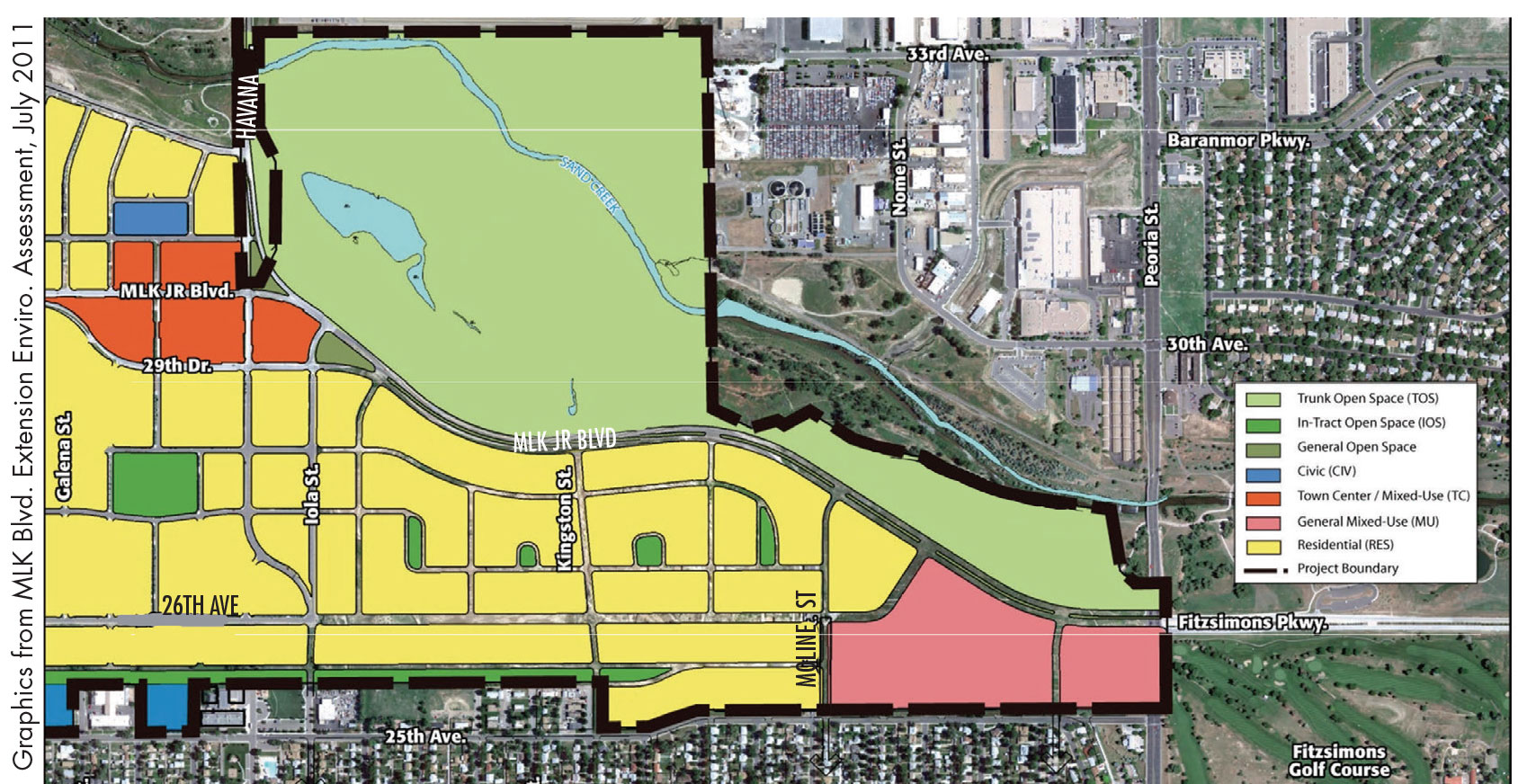
According to the color coded map, the area east of moline, bordering MLK blvd at the north and 26th ave at the south is “yellow” or residential. According to other maps this whole area east of moline is classified as general mixed use. Wondering which one is correct.
Forest City confirmed that currently the expected use of that land is residential.
Will this construction have any effect on Quince Street?