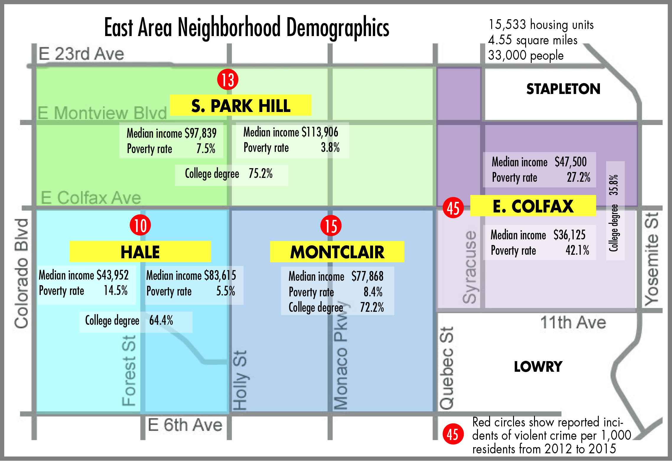
The City of Denver is inviting residents and business owners in South Park Hill, Hale, Montclair and East Colfax to participate in developing the “East Area Plan” for their neighborhoods. Although their boundaries haven’t changed since 1970, these neighborhoods have been subject to many internal changes: population growth, rising housing costs, traffic congestion and major new development such as the 9th and Colorado mixed-use project. Stapleton and Lowry, with their own more recent development plans, are not in the East Area planning project.
A major focus of the project will be to identify impacts, pro and con, of the proposed Colfax Bus Rapid Transit system (BRT). Denver residents will vote on a bond in November for transportation improvements that include $55 million for the BRT.
The BRT plan calls for a dedicated center lane from Auraria to Yosemite and continuing east to the Anschutz Medical Campus (though Aurora has resisted reserving a lane of traffic for the BRT, instead wanting it to run with traffic).1 Simultaneous with the East Area planning effort is a transit-oriented development plan that is focusing on how best to take advantage of a Colfax BRT while avoiding displacement of vulnerable populations and businesses.
While the Colfax corridor, in a sense, unifies the entire East Area, issues within the neighborhoods differ significantly. East Colfax in particular stands out with a greater housing density, higher poverty and crime rates and lower household income and education. The planners’ charge is to develop recommendations that will enable all the East Area neighborhoods to benefit from expected growth.
Neighbors can participate in the planning process through focus groups and public workshops or through social media and email alerts. An on-line survey seeks neighbors’ likes, dislikes, concerns and “big ideas” for improving the East Area. The survey and project schedule can be accessed at the project website: www.devergov.org/eastplan.
Additional topics to be addressed in the two-year planning project include land use, urban design, affordable housing, mobility, economic development, health and “green” infrastructure (stormwater drainage, water).
The East Area Plan is part of a larger effort to update neighborhood plans in many areas of the city. Conclusions from these planning efforts will be integrated into the Denveright project, the first comprehensive city plan update since Blueprint Denver in 2000.2
The first two Steering Committee meetings for the East Area, convened by Council Members Chris Herndon and Mary Beth Susman, were held July 26 and August 23.
At the August 23 Steering Committee meeting, members took the on-line survey, using hand-held clickers to generate instantaneous polling results. Among the conclusions:
- The neighborhood is not “easy” to walk or bike in
- Most residents “usually feel safe”
- The neighborhood needs more housing options
- The top three amenities are shopping (especially for groceries), dining and cultural amenities and events.
Denver planners reported they have received 380 responses to the survey. The survey will remain open on line through September at least.
The group was also asked to identify their “big ideas” for transforming or changing the neighborhood. Little disagreement was heard about these proposals:
- Conversion of motels to other uses, including possibly affordable housing.
- Addition of parks, possibly integrated with storm drainage improvements currently under study. Note: the Upper Montclair Basin is the largest in the city without an open drainageway.
- Finding ways to “leverage” the city’s anticipated investment in bus rapid transit by adding medium density housing in “transit villages” near the BRT stops.
- Anchoring the neighborhood with “safe, vibrant” schools serving a diverse mix of students. Developing more affordable housing was seen as one tactic for supporting the diversity goal.
One idea elicited chuckles and delight: to convert the 13th and 14th Avenue one-way streets into a pedestrian zone. The idea was duly recorded because at this early stage of a long process, no idea gets summarily rejected.
1- https://frontporchne.com/article/making-colfax-walkable-main-street-efficient-transit-corridor/
2-https://frontporchne.com/article/get-involved-make-denveright/


Correction: As of the steering committee’s August 23, 2017 meeting 880 participants have completed the East Area Planning Initiative Survey which covers all the neighborhoods between Colorado Boulevard and Yosemite. We have received 1200 individual comments via completed surveys.