


 Ever been driving on a winding road late at night, only to round a bend and have to slam on the brakes to avoid rocks in the road? If so, you’re not alone. Rockfalls are regular occurrences in Colorado, and the debris they jettison onto roadways and other structures is hazardous.
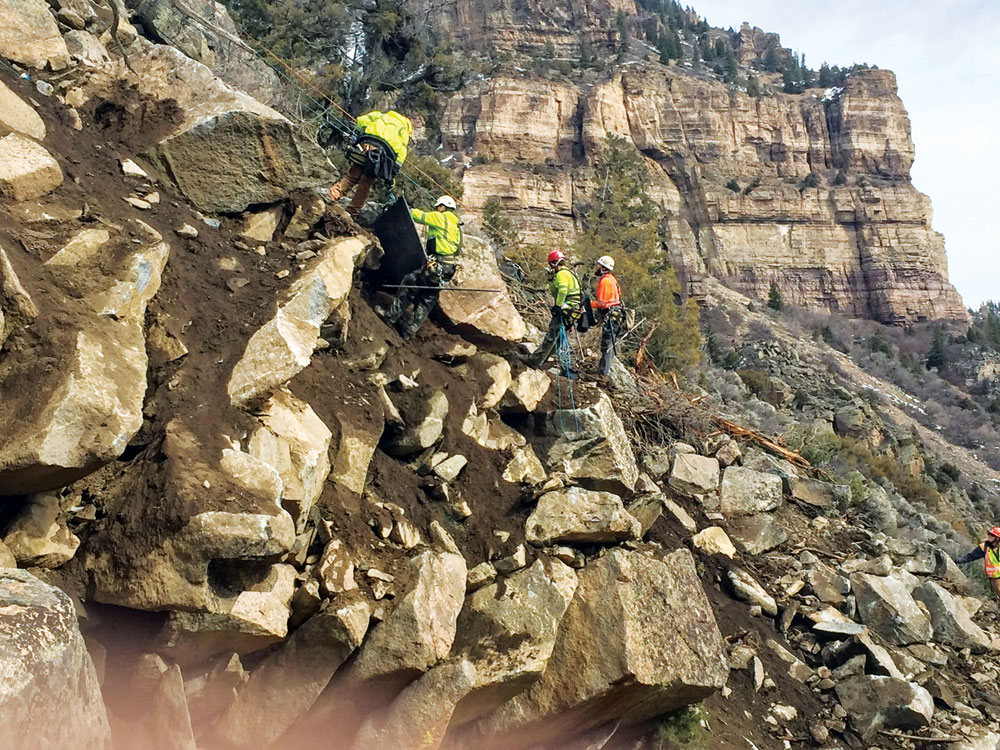
Crews assess precipitously perched rocks above the road—the source of the recent rockfall in Glenwood Canyon.
Fortunately, Colorado’s got some of the top gurus in the nation to track these geohazards, including teams at CDOT, at CGS, and their partners. Using laser mapping, aerial photography, remote sensing, and a bevy of crack-, tilt-, and movement-meters, they regularly assess and monitor our known rockfall regions. The data is plugged into modeling software to assess the nature of potential future slope failures. In fact, the most widely used modeling software for characterizing rockfalls was developed right here in Colorado. It arose from the need to minimize risk from snaking an interstate through Glenwood Canyon. To head off future falls, whether in Glenwood or in the seemingly innocuous hillsides of South Park, agencies build preventative berms, moisture-diverting sluices, rock-catching troughs, fences and walls. Known problems get remediated with an arsenal of bolts, buttresses, cables, anchors, netting and related gear. Sometimes crack-filled exposures are even injected with vast quantities of resin—akin to mountain super glue.
But what is it about our landscape that makes all of this prevention necessary? After all, New Mexico, Utah, and California have huge mountains but they don’t have as many catastrophic rockfalls. Short of blaming population penetration of the mountains, Colorado’s rockfall abundance stems from our distinctive climate, topography, and diverse blend of rock types.
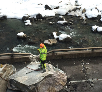
Crews assess the recent damage to the road deck in Glenwood Canyon. Photos by CDOT.
In Colorado, falling rocks mainly come from three sources, all of which are plentiful in hillsides and mountains. The first source is fractured bedrock like the stuff exposed in Black Canyon of the Gunnison, Golden’s Clear Creek Canyon, and Pikes Peak. These rocks, cooled from magma or cemented together during burial and mountain-building, are full of fissures and cracks. As water seeps into the cracks, sometimes it lubricates them or degrades crack-filling crystals into clays that help the rocks slip apart. The rocks eventually calve off like glaciers. An even more destructive process, called ice-jacking, occurs when this infiltrating water freezes and expands, gradually wedging the rock’s cracks open more and more during the daily and seasonal freeze-thaw cycles.
Alternating layers of sedimentary rock are the second major contributor to rockfalls. In exposures like those that rim Castle Rock, Durango, Grand Junction, and Manitou Springs, massive cliff-forming beds of these rocks regularly spall off from mesas, buttes, and bluffs. The cause? Underlying the durable well-cemented cliff rocks are soft mud-rich layers. These layers erode from rainfall and seepage, undercutting and allowing the overlying rocks to topple downhill. Ice-jacking of cracks in cliff-rocks also contributes.
Relict soils and sediments (those not in their typical environment) left behind by ancient landslides and the bulldozing of Snowmastodon-era glaciers are the last source of falling rocks.
These crazy-looking piles of dirt and rock are a geological mishmash of giant boulders suspended in sand and gravel. They line most of Colorado’s valleys and canyons. As water from snowmelt or rainfall saturates sediment that holds boulders in place, rocks can slip or fall out of these piles, tumbling down to burgs like Cañon City or the geological bullseye of East Vail.
Falling rocks from these sources directly impact homes, vehicles, infrastructure, and people. They have indirect impacts as traffic hazards and because they catalyze landslides. To add to natural triggers, anytime we undercut, oversteepen, or disturb hillsides and mountainsides, rockfalls will be more likely. Ditto when we build roads and homes at the foot of, or on top of ancient rockfalls and landslides.
Given that Colorado’s freeze-thaw cycles and rainfall are each three-season phenomena, it isn’t surprising that crack-related rockfalls are a year-round phenomenon. Witness the epic traffic-clogging examples on the I-70 corridor. In contrast, erosion- and slippage-related rockfalls tend to occur after prolonged or massive rainy intervals, especially when it’s windy. Highway 133 between Paonia and Carbondale is a classic example.
Rockfalls have been shaping the surface of our state for a billion years, and will continue to do so. They’re an indication that our earth is always in action, and they signal the risks of living and playing in mountainous and hilly terrain. Understanding what triggers them and how they behave helps us predict and minimize our risk. To learn more, check out coloradogeologicalsurvey.org/geologic-hazards/ or codot.gov/programs/geotech/.
James Hagadorn, Ph.D., is a scientist at the Denver Museum of Nature & Science. Suggestions and comments are welcome at jwhagadorn@dmns.org.

Thanks, Jasper. Indeed, while we can’t prevent 100% of rockfalls, it is amazing how safe our roads have become given the canyons our roads snake through.
I remember being a child, driving through the canyon had an added thrill when I saw signs warning drivers about falling rocks. I am sure that my child self would have been much less scared of them if someone had explained to me that There are methods that can be taken to prevent these falls. I think the article touches on what seems to me to be the most important step. This would be understanding the sediment of the canyon wall to strengthen it in the right places.