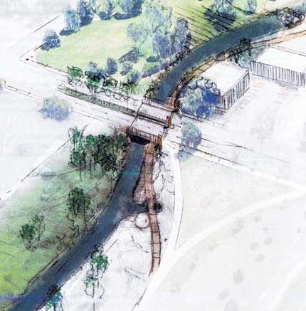
This conceptual drawing of the Montview Boulevard bridge shows it will be designed so daylight enters between the lanes to provide light for the pedestrian/bike path under the structure. Specific design elements have yet to be determined. (photo provided by Aurora Water Operations & Maintenance)
Ten years ago, Park Hill residents Marcia Johnson (a former city councilwoman) and Brian Hyde were bold enough to imagine a continuous greenway along Westerly Creek from Lowry to Stapleton, though the reality seemed far in the future. “It’s so logical,” says Johnson, who spearheaded the project for the Westerly Creek connection when she took office in 2003. “The two biggest infill projects, Lowry and Stapleton, are only nine blocks apart, nine blocks, and there are wonderful amenities in both. If there was a comfortable path, people would actually use all of those.”
Westerly Creek has been a convoluted path, or a dotted line according to Johnson. Parts take right angles, some go through gritty urban areas with underused or vacant buildings, and sections of the creek are not daylighted, they flow through underground pipes. But piece by piece, the creek is beginning to resemble the early vision.
The City of Denver has created a plan for a park along Westerly Creek in the two blocks north of 11th, and is looking for funds to build it. This new park will connect to New Freedom Park, at 13th and Xenia, which was a dirt field of glass before it was turned into a park with a community garden in 2012 for the surrounding refugee community. However, Westerly Creek cuts through the middle of the park, limiting access between the two sides of the creek and making it potentially dangerous, according to William Wenk, principal at Wenk Associates Landscape & Architecture Planning. Just this September, the creek swept a blind man and his dog two blocks downstream until police rescued them. The U.S. Environmental Protection Agency hired Wenk Associates to regrade the channel there and build a new crossing.
“Westerly Creek is a big part of our general improvement of Denver’s waterways,” says Mary Beth Susman, city councilwoman for District 5. “This section (the two blocks north of 11th Ave.) is particularly significant to our recent creation of New Freedom Park and to the enjoyment and safety of neighbors. I am hopeful we will find the right partners to help us implement this beautiful plan in 2014 or 2015.”
Another upcoming improvement within the Westerly Creek corridor is a new vehicular bridge across the creek on Montview Boulevard. Currently, Westerly Creek flows under Montview Blvd. through two grossly undersized culverts, causing a major backup of water during flood conditions, like those in September 2013. That backup puts 107 properties in the 100-year floodplain south of Montview Blvd. The Aurora Water Department applied for and was awarded a FEMA grant to replace the existing culverts with a 60-foot-wide bridge that will have daylight between the lanes to enhance the pedestrian trail below. Aurora Parks will reshape the creek channel through Montview Park, extending the current greenway at Stapleton south from Montview to 17th Ave. The department also bought and tore down a gas station north of Montview along the east side of Westerly Creek to create a wider, more attractive stream bank and to accommodate emergency vehicles under the bridge. Construction will begin in 2014 and will be completed by June 2015. Aurora Parks is simultaneously planning improvements to Montview Park, which will improve pedestrian access along Westerly Creek from Montview to 17th Ave. The bridge is funded by a partnership between the City of Aurora, the Federal Emergency Management Agency (FEMA), and Urban Drainage Flood Control District (UDFCD).
After Aurora finishes the Montview bridge and park and Denver finishes the two blocks north of 11th Ave., only four blocks, from 13th to 17th avenues, will remain to create a pedestrian path from Stapleton to Lowry.
“It’s now a hint of what I imagined,” Johnson says.


I appreciate this coverage and you have it exactly right about what this corridor could become and who the partners are. When complete people will use the open space, which will make the whole area safer and lift the value of nearby properties. Marcia Johnson