

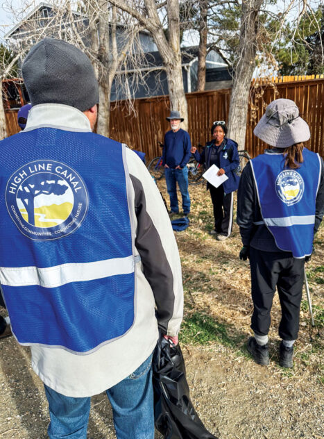
The High Line Canal Conservancy, a non-profit that promotes and protects the historic waterway, organizes numerous recreational, educational, and cleanup events every year. Front Porch photo by Christie Gosch
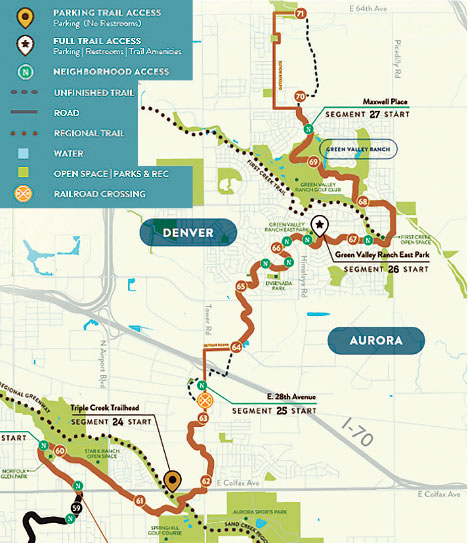
It’s one of the longest urban trails in the nation and it’s about to get some major upgrades in the Northeast Denver metro area. Construction has begun to connect one of the last remaining gaps in the 71-mile-long High Line Canal trail: from a newly built trail in Aurora to the existing trail in Green Valley Ranch. It will involve the construction of a bike and pedestrian bridge across I-70, improved lighting, new park benches, and potentially outdoor fitness stations and nature play areas. Construction is expected to be finished by the spring of 2024.
Suzanna Fry Jones, Senior Director of Programs & Partnerships for the High Line Canal Conservancy, says her organization has spent years working with neighborhood leaders and youth ambassadors in the Northeast to find out what residents would like to see in trail improvements. “We know they want better access to the trail, more safety features, and better signage. But we also want to let community members dream about other enhancements that can be made to really encourage residents to use the trail.”
The Conservancy’s focus in the northeast part of the metro area is relatively new, but for many years the non-profit has held numerous community events along other parts of the trail, including cleanups, tree plantings, brush removal, guided bike rides, and walking tours–as well as educational events in schools. “We love going into classrooms and engaging with young children on environmental issues and even on the issue of water in the West,” says Fry Jones.
The High Line Canal trail zigzags northeast from Waterton Canyon to the Rocky Mountain Arsenal, providing recreation opportunities for a million people every year.
The High Line Canal has a long and rich history. It was originally built in the 1880s to deliver irrigation water from the South Platte River to farms near the growing city of Denver. The trail meanders for 71 miles northeast from Waterton Canyon to the Rocky Mountain Arsenal, and it uses a “high line” principle of design that follows the highest contours of land so that the water flows by the pull of gravity rather than being pumped by devices. Twisting and turning, the Canal drops on average two feet every mile. The canal was acquired by Denver Water in 1924, although it was never a very efficient means to deliver water since much of the water evaporated or seeped away. The agency is currently transitioning the function of the canal from delivering irrigation water to receiving storm water to prevent communities from flooding and help vegetation along the canal thrive.
Beginning in the 1970s, the maintenance road along the canal was opened to the public for recreation, and over the last 50 years it has become an extremely popular destination for cyclists, runners, walkers, and even equestrians on parts of the trail. More than a million people use the trail every year. The 860-acre corridor connects with more than 8,000 acres of other parks and open spaces.
Josh Phillips, Director of Planning & Implementation at the High Line Canal Conservancy, says that like many outdoor places, the High Line Canal trail saw a huge spike in the number of recreationists during Covid. “We really saw an increased desire of people to connect with nature in the city. They sought out the trail as a natural refuge. That combined with the general population growth in the city, means we are seeing more and more users every year.”
Phillips works with 11 different municipal jurisdictions helping to raise funds to maintain the trail and surrounding watershed. Earlier this summer, Great Outdoors Colorado (GOCO) awarded the Conservancy $350,000 for its work to restore and protect the canal area. It was the third major donation from GOCO to make trail improvements. The current construction in the northeast section of the trail is part of a 15-year, $130 million capital improvement project that will include safety enhancements, focused especially on dozens of intersections where the trail crosses roadways. “Safety is a key priority and we need to secure funding to add additional underpasses to improve the safety of traveling along the canal,” says Phillips. “We’re also focused on increasing accessibility. At many locations, crossing the ditch itself can be a barrier, so we’re trying to build more bridges along the trail.”
The capital improvement plan also calls for planting 50 new trees per mile to maintain the tree canopy as older trees begin to die. And the trail itself will be resurfaced starting with a section in Denver near the Windsor Gardens community. The concrete trail will be widened to 12 feet, with a 6-foot gravel path on the side for runners and walkers. “As more and more people use the trail, it’s good to provide options to help separate the walkers from the bikers and remove any conflicts between different users,” says Phillips. The hope is for that design to become the model for how the entire trail will be refashioned.
When the City of Aurora completes the new I-70 trail section, there will be just two gaps remaining in the High Line Canal trail system. One is located at Plum Creek in Douglas County and involves private land and a railroad crossing. Phillips says that gap has some difficult challenges to overcome. The other remaining gap is north of Green Valley Ranch going into the Painted Prairie development where the historic canal ended. That trail is expected to be built in 2024.
0 Comments