Planted areas are still off limits
but portions of the new park will be open for public use on June 1. Restrictions are as follows:
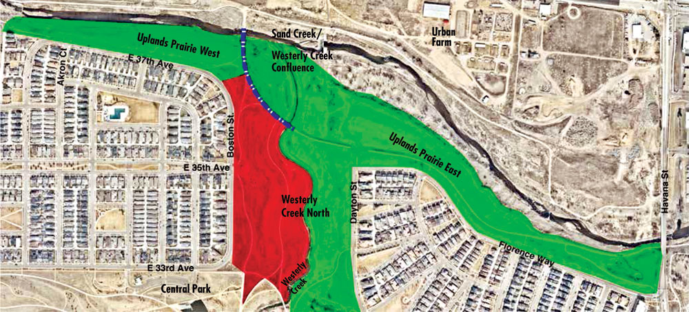
Areas in red: parks and trails are closed.
Areas in green: concrete and crusher fine trails in this area are open but park and open space are off-limits.
Dashed blue line: concrete trail open through closed construction area. For safety reasons, users must stay on the trail.
Vegetation needs to get established in the off-trail open space before the public can access it. Charlie Nicola, vice president of Forest City, says the balance of the park will be open by November 2016, adding it is essential that residents honor the use restrictions. This project has been a major investment that serves not only a park function but also flood mitigation and water quality goals. Trails in the “red” area depicted on the map are anticipated to open by September 2, 2016, says Nicola.
The $12 million project began in March 2015 and rehabilitates the remaining 64 acres of Westerly Creek Park (roughly, that portion north of the Central Park Recreation Center). Ironically, were it not for major flood events in July last year, the entire project might have been opened in December 2015.
The overall project included major landform shaping, removal of construction rubble, streambed realignment, revegetation and new trail construction. The new park provides major new connectivity to the Sand Creek Regional Greenway at the confluence of Westerly Creek and Sand Creek.


0 Comments