Colorado has some of the strangest mountains and plains on earth. Their tectonic history underpins our ski industry, groundwater supplies, soil, and national parks.
We even have a couple of hidden mountain ranges, whose whereabouts are revealed in rock outcrops that millions of people drive by every day. These mountains were once as big as the Andes, and corrugated our state 300 million years ago when Colorado was a warm, tropical locale that straddled the equator. One range called Uncomphagria (rhymes with sangria) loomed over western Colorado. The other, called the Ancestral Rockies, towered over central Colorado.

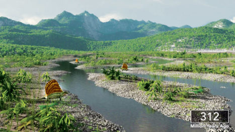
This is what it would look like if you were standing at the foothills of the Ancestral Rockies, hundreds of millions of years ago. Wander through this landscape at https://vimeo.com/coloradoigp Image: P. Weimer.
Tropical weathering and millions of years of erosion eventually beveled the peaks of these mountains. Their relicts live on, though. The pebbly remnants of Uncomphagria make up much of the red dirt and rocks of southwestern Colorado. The sedimentary remains of the Ancestral Rockies make up the Flatirons, Red Rocks Amphitheatre, Roxborough Park, and Garden of the Gods. The most famous leftovers of these mountains make up the Maroon Bells. To get these bottom-of-the-mountain sediments up to the top of Maroon Peak, another mountain-building interval occurred hundreds of millions of years later. Movement of earth’s tectonic plates squeezed our modern Rocky Mountains into existence, opening them upward like an accordion.
And those diamond-shaped peaks coveted by skiers and outdoorspeople? They owe their origin to ice ages that occurred during the last couple hundred thousand years. That’s because as snow builds up on mountaintops, it compresses and eventually becomes ice. If enough of it accumulates, and if it persists for millennia, it forms a glacier that then flows downhill like molasses. But glaciers chisel a path through mountains like an ice-cream scoop carves through ice cream. The areas left between the glacial scoops formed the pointy peaks and knife-sharp jagged ridges that adorn our favorite ski and mountaineering epicenters. They also created all the depressions that became our alpine lakes, like Turquoise Lake near Leadville. As glaciers moved downhill and combined with one another, they bulldozed long valleys with flattish bottoms. In some cases, we’ve shored up their bulldozed piles of debris with dams, turning them into drinking water reservoirs.
We also have two sets of mountains that break tradition. That’s because they don’t have pointy peaks, but rather are flat-topped. The most famous of these is near Coors brewery. Not too long after the dinosaurs bit the dust 65 million years ago, a volcano northwest of Golden spewed hot lava. It flowed southward, filling up valleys like a lake. Over time, the mountains surrounding this cooled lava lake eroded away, but the hardened lava rock was durable, and protected the underlying strata from erosion. Thus formed North and South Table Mountain. The same thing happened in an area between Steamboat, Meeker and Glenwood Springs. It formed our other rule-breaking mountain range, called the Flat Tops.
So why do we have so many fourteeners, even compared to volcano-rich places like California and Washington? You’d think that only the edges of continents, where the tectonic plates are ramming into one another, would have giant mountains. Like the Himalayas, Andes and Alps.

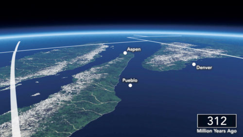
Satellite view of Colorado with the Uncompahgre Mountains in the distance and the Ancestral Rockies in the foreground, separated by inlets of a vast sea that covered most of North America. See animation of how Colorado evolved during this interval at https://vimeo.com/coloradoigp Image: P. Weimer.
Moreover, why are our “plains” a mile high?
It’s because about 10 million years ago, Colorado and vicinity began to be uplifted like rising cake batter. Rivers and glaciers cut downward into the rocks and sediments underfoot, exposing them and sculpting the landscape we have today. In some cases, big piles of sediment were washed out onto the plains, creating the largest reservoir of groundwater in the U.S.—the Ogalalla aquifer. Where rivers got “stuck” in our mountains’ resistant bedrock, they cut deep v-shaped chasms like Royal Gorge, Glenwood Canyon, and Black Canyon of the Gunnison.
Just last year, scientists figured out why this happened. Water from a melting tectonic plate that long ago got shoved under North America percolated upward beneath what’s now our High Plains. It transformed the overlying minerals and rocks, making them less dense. And Colorado became more buoyant, rising like a marshmallow floating on the earth’s inner hot cocoa. Nature’s erosional processes did the rest, with rivers, wind and ice dissecting the landscape and redistributing its sedimentary bounty.
The Rockies will still periodically be punctured by volcanoes and cracked apart by tectonic movements, but not in our lifetimes. Yet our mountains and plains are still gently rising. As a result, the Rockies are slowly eroding away and being deposited on the High Plains, making our landscape less lumpy over time. But don’t worry, you’ll still have plenty of time to bag some peaks before the Rockies end up in Kansas.
James Hagadorn, Ph.D., is a scientist at the Denver Museum of Nature & Science. Suggestions & comments welcome at jwhagadorn@dmns.org


Absolutely! The science in which this article is grounded is all public domain, so feel free to use my rendition of it in any way you think would help. Hope it fits with your work at Roxborough.
James:
This is a great article. I volunteer at Roxborough State Park. May I use some of the facts you stated in the context of your presentation when I give a talk at the Park? I will, of course, give you full credit for the information.